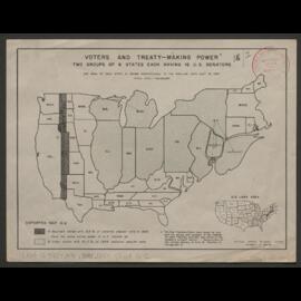
Distorted Map - Area of each state is drawn proportional to the popular vote cast in 1944. Sheet G-1.
Sans titreDistorted Map - Area of each state is drawn proportional to the popular vote cast in 1944. Sheet G-3.
Sans titreDistorted Map - Area of each state is drawn proportional to the popular vote cast in 1944. Sheet G-0.
Sans titreDistorted Map - Area of each state is drawn proportional to the popular vote cast in 1944. Sheet G-2.
Sans titreDistorted Map - Area of each state is drawn proportional to the popular vote cast in 1944. Sheet G-8.
Sans titreUpper Silesia Plebiscite results and borders delimitation.
Sans titreAnnotated with colouring of mines and resources.
Sans titreAnnotated with colouring of mines and resources and an unlabelled boundary line.
Sans titreAnnotated with colouring of mines and resources.
Sans titre