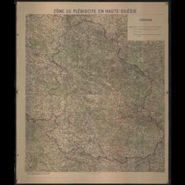
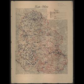
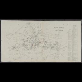
Map depicting Counties in which referendums are held and occupied territories around Eupen, Malmedy and Saargebiet. Inset maps of Voting area of North Schleswig and surrounding ares of Malmedy. Cover on reverse side including several articles: "What every German needs to know about the vote", "Schleswig, article 109", "West and East Prussia", "Upper Silesia, article 88", "Eupen-Malmedy, article 34".
Untitled
41 results with digital objects
Show results with digital objects
LON-G6081.F3 1919 .D54
·
Item
·
[192-?]
Part of Collections
LON-G6522.S5F2 1920a .S43
·
Item
·
1920
Part of Collections
Map depicting electoral zones and boundaries. With annotations on reverse side.
Untitled
LON-G6522.S5F9 1921 .S55 Copy 10
·
Item
·
1921
Part of Collections
Annotated with colouring of mines and resources.
Untitled
LON-G6522.S5F9 1921 .S55 Copy 7
·
Item
·
1921
Part of Collections
Annotated with colouring of mines and resources.
Untitled
LON-G6522.S5F9 1921 .S55 Copy 3
·
Item
·
1921
Part of Collections
Annotated with boundary "Line D", "Line B", Lines "I", "II", "III". Upper Silesia Plebiscite results and borders delimitation.
Untitled
LON-G6522.S5F2 1921 .S43 Copy 3
·
Item
·
1921
Part of Collections
Map depicting electoral zones and boundaries.
Untitled
LON-G6522.S5F9 1921 .P74
·
Item
·
1921
Part of Collections
Title and Legend in French and Spanish. Note on map: Gift of the German consul, Geneva.
Untitled