LON-G3701.F7 s000 .U55 Sheet G-2
·
Item
·
1945
Part of Collections
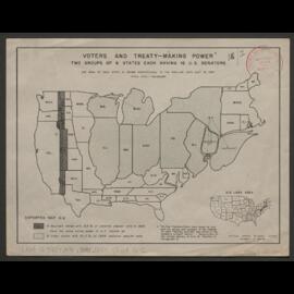
Distorted Map - Area of each state is drawn proportional to the popular vote cast in 1944. Sheet G-2.
National Opinion Research Center
LON-G6522.S5F9 1921 .S55 Copy 10
·
Item
·
1921
Part of Collections
Annotated with colouring of mines and resources.
Untitled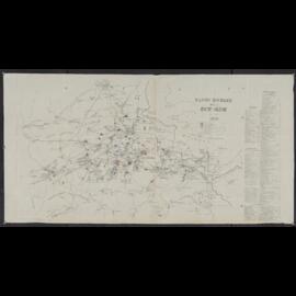
LON-G6522.S5F9 1921 .S55 Copy 7
·
Item
·
1921
Part of Collections
Annotated with colouring of mines and resources.
Untitled
LON-G6522.S5F9 1921 .S55 Copy 3
·
Item
·
1921
Part of Collections
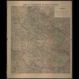
Annotated with boundary "Line D", "Line B", Lines "I", "II", "III". Upper Silesia Plebiscite results and borders delimitation.
Untitled
LON-G6522.S5F9 1921 .S55 Copy 8
·
Item
·
1921
Part of Collections
Annotated with colouring of mines and resources and an unlabelled boundary line.
Untitled
LON-G6522.S5F9 1921 .S55 Copy 11
·
Item
·
1921
Part of Collections
Annotated with colouring of mines and resources.
Untitled
LON-G6522.S5F9 1921 .S55 Copy 6
·
Item
·
1921
Part of Collections
Annotated with colouring of mines and resources and an unlabelled boundary lines.
Untitled
LON-G6522.S5F9 1921 .S55 Copy 2
·
Item
·
1921
Part of Collections
Upper Silesia Plebiscite results and borders delimitation.
Untitled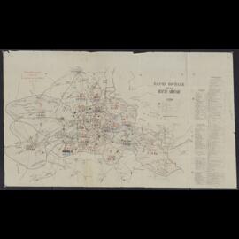
LON-G6522.S5F9 1921 .S55
·
Item
·
1921
Part of Collections
Upper Silesia Plebiscite results and borders delimitation.
Untitled